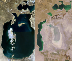
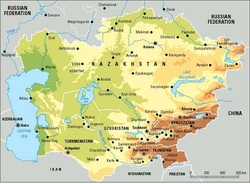
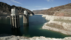
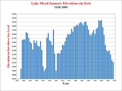
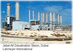
 What is left of the Aral Sea, (literal translation; the Sea of Islands) which was once half the size of England, is in Midwestern Kazakhstan and gives “unintended consequences” new meaning. Today those islands of the Aral Sea rise from the dry sea bottom like Mesa’s of western Texas. Up until the last part of the 20th century, it was the world’s 4th largest saline lake containing 10 grams of salt/liter. The two rivers that feed the lake are the Amu Darya and the Syr Darya. The Amu Darya river is amongst the largest rivers in Central Asia which flows north from the mountains and empties into the Aral Sea. It is 1500 miles in length and 900 miles of it are navigable to boat traffic. The Syr Daryu river flows northwesterly into the Aral Sea from its origination point in the Tian Shan mountains in Kyrgyzstan. The Syr Daryu is approximately 1300 miles in length but has half the water content of the Ama Daryu (not as deep or wide). Even before large scale irrigation projects began, high summer evaporation meant that not all of the waters from these two rivers reached the Aral Sea basin. In the 1960’s, the Soviet Government built canals from these rivers in order to irrigate cotton fields and other agriculture projects in the desert area south of the lake. As a result, the water level of the Aral Sea began to decline drastically in the late 1960’s while at the same time causing the salinity levels to rise. By 1998, the sea was 10% of its original size.  The water level was down by 75 feet and the salinity had risen to 100 grams/liter; the increased salinity and decreased water levels has all but destroyed the fishing industry on the sea that is now 4 separate lakes and has dried up Marina’s and left countless boats stranded on the bare bottom. The sea’s evaporation has also left layers of highly salted sand which is carried aloft by winds and has been detected as far away as Japan. In order to view a time lapse exposure of the lakes demise, click on the following link; http://www.youtube.com/watch?v=cbSkRS8Ih7o. The Aral Sea’s level dropped by an average of 30-35 inches/year to its current level. In 2005, a number of dams were built to try and reclaim the sea, but progress is slow and continued irrigation projects and rising population take its toll.  Let’s now go half way around the world to Lake Meade in Nevada and Arizona. Lake Meade was formed by the construction of the Hoover dam (originally Bolder dam), which was completed in 1935 after construction began in 1931. Hoover dam is the second largest dam in America generating 2080 Megawatts of electricity (the largest is the Grand Coulee on the Columbia River in Washington state). At its formation, Lake Meade’s water level was 1165 feet above sea level and reached highs during the 1980’s of over 1210 feet. Lake Meade is currently 1106 feet above sea level which is below the drought level of 1125 feet. To no surprise, many people are attributing this to global warming; however, from 1953 to 1956, the water level fell from 1200 feet to 1085 feet and from 1963 to 1965, the water level fell from 1205 feet to 1090 feet (no mention of global warming during those periods!). What is disconcerting is the continued dropping of the lake’s level since 2000. Global warming? Hardly.  The Colorado river, which is the major source of replenishment for Lake Meade, is also the primary water supply for Las Vegas Nevada and suburb’s, northern Arizona and southern California. But wait, as a result of the housing boom in those states in the 1st decade of this century, the population of California since 2000 increased by 4 million, Nevada .7 million and Arizona 1.4 million for a total increase of 6.1 million; and all these people need water which is coming from Lake Meade, and the 1450 mile Colorado river basin. “In addition, agriculture from California’s Imperial Valley to Wyoming’s cattle herds uses about 75% of its water and produces 15% of the nation’s food” (NY Times). What appears to be drying out Lake Meade is also what dried out the Aral Sea, extensive use by man. Currently those states are utilizing conservation measures; Arizona farmers are reducing runoff by utilizing laser technology to ascertain their fields are flat, southern Nevada is treating all “gray” water (water from showers, dishwashers etc) and returning it to Lake Meade and California is even recycling some sewage effluent. Like the Aral Sea, Lake Meade’s main problem is over use and new sources of water must be utilized in addition to conservation.  As an afterthought, 60% of The UAE’s water is from de-salination plants (which is very energy intensive) and they are the world’s 3rd largest user of water per capita in the world.
0 Comments
Leave a Reply. |
AuthorJohn Tommasi is a retired Senior Lecturer of Economics & Finance from Bentley University and the University of New Hampshire. Archives
February 2023
Categories |